
The Evolution of Aerial Mapping: From Balloons to Drones
Aerial Mapping has been around way longer than most people think. These days, everyone talks about drones like they’re some brand-new miracle tool, but folks have been trying to capture the world from above for well over a century. Funny thing is, the idea hasn’t changed much, but the tech sure has. What started with hot air balloons wobbling in the wind has now become entire fleets of automated aircraft capturing insanely precise data that used to take months to collect.
If you take a wider perspective, the development of Aerial Mapping is fundamentally a narrative about mankind's desire to see more, understand more, and measure things accurately without having to climb mountains or cut paths through the jungle. And every couple of decades, a new person appeared with a novel idea, a balloon, a kite, an aircraft, and presently drones and ultra-high-resolution sensors, which made the whole discipline advance.
This isn’t some dramatic “technology revolution” speech. It’s just the timeline of how we got from blurry, shaky photos to centimeter-accurate 3D models that help engineers, energy companies, surveyors, and city planners make smarter choices every day.
Balloons: The Wobbly Start of Everything
The early days of Aerial Mapping were, let’s call them, “experimental.” Back in the mid-1800s, people were strapping giant cameras to hot air balloons. The photos were rough and shaky, and you can imagine how unstable that whole setup was. Still, it worked well enough that the military and scientists started paying attention.
Balloons didn’t fly fast, didn’t fly high, and barely steered at all, but they gave people something absolutely priceless at the time: a top-down view. For the first time, you could see an entire landscape in one shot without having to climb anything.
It wasn’t perfect, but it sparked something big.
Kites Enter the Scene (Surprisingly Effective)
Kites were the next clever twist. They were cheaper and easier than balloons, and you didn’t need fire, fuel, or any fancy setup. You just needed wind, which sometimes made the whole thing a complete mess, but when it worked, it actually worked pretty well.
People would attach cameras with little timed triggers and send the kite up. The results were sharper and more stable than balloon shots. For documenting coastlines, farms, and cities, this was a mini-breakthrough. Still slow. Still unpredictable. But a huge step forward.
Airplanes: The True Game Changer
Once airplanes entered the picture in the early 1900s, everything changed. Aerial Mapping suddenly became reliable, repeatable, and scalable. You could cover massive areas quickly. You could fly over rough terrain, deserts, mountains, and war zones. This is when mapping became serious business.
By the mid-1900s, governments, survey companies, and engineering firms were flying routine mapping missions using film cameras mounted to the underside of planes. The photos were crisp. Thousands could be captured in a single flight. And photogrammetry, the science behind turning images into maps, finally became accurate enough to trust for real planning.
Most of the maps people used for decades were created from airplane photos. In fact, some countries still update certain regional maps with traditional aircraft today because the method still works.
Digital Cameras, Satellites & the Data Burst
Once digital cameras and satellites came into play, aerial data basically exploded. You didn’t need to wait for the film to develop anymore. You didn’t need perfect weather conditions for every shot. You could launch imaging satellites and get global coverage.
Satellites were great for large-scale mapping, stuff like tracking weather, studying forests, watching coastline erosion, and planning big infrastructure. But satellites have their limits:
They can’t fly low.
Clouds mess everything up.
Resolutions aren’t always good enough for engineering work.
So airplanes were still used a lot for exact, up-close mapping. But something else was about to take the lead.
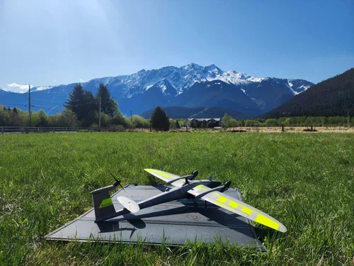
Drones Arrive: The New Standard for Precision
Drones didn’t just “upgrade” Aerial Mapping; they completely flipped the industry on its head. Suddenly, you could collect extremely precise data without booking an airplane or hiring a pilot. You didn’t need huge budgets. Small teams could map enormous areas with sharp detail, and they could do it weekly or even daily if needed.
Some of the biggest advantages drones brought:
1. Insane Level of Detail
Drones fly low and slow, which means they capture super-high-resolution imagery, sometimes down to single-digit millimeters.
2. Accessibility
A company doesn’t need to spend six figures to get started. One drone can handle jobs that used to require aircraft.
3. Safety
Inspecting power lines, bridges, roofs, and towers became way less dangerous. No need to send workers climbing up anything.
4. Fast Turnaround
What once took months can now be done in the morning.
5. 3D Everything
Modern software can turn drone imagery into detailed 3D models, contour maps, orthomosaics, and elevation grids, the kind of stuff engineers love.
Organizations in energy, construction, surveying, and even agriculture are now running drone programs like it’s just another part of daily operations. And companies like Cleartopia Solutions are helping teams not only get the right hardware, but also learn the software, processing workflows, and field techniques needed to do the job right.
If you’re trying to get into Aerial Mapping or upgrade what you already have, you can check them out here.
Where Aerial Mapping Is Heading Next
The next wave isn’t really about drones themselves; it’s about automation and smarter processing.
Autonomous flights that plan missions, adjust routes, avoid obstacles, and gather consistent data.
AI-powered processing that turns imagery into finished maps and reports automatically.
Real-time data streaming, where your drone sends usable mapping data as it flies.
Bigger sensors like LiDAR are getting smaller and cheaper.
Cloud-based map libraries, so companies can access massive datasets instantly.
The future of Aerial Mapping is basically faster, smarter, safer, and more accessible than anything early balloon photographers could have dreamed of.
Conclusion
Aerial Mapping has come a long way, moving from shaky balloon snapshots to drones that deliver crisp, reliable data in minutes. The challenge now isn’t capturing imagery; it’s making it useful, consistent, and easy to work with across different projects.
That’s exactly where we come in. At Cleartopia, we help teams choose the right gear, build solid workflows, and avoid the usual headaches that slow mapping jobs down. We make modern aerial data easier to adopt and far more practical.
[Start your next step with us]
FAQs
1. Why are drones more efficient for Aerial Mapping than airplanes?
Drones fly lower, capture tighter details, and don’t require expensive pilots or aircraft logistics. They’re faster, cheaper, and great for small and mid-size mapping jobs.
2. Can drones replace satellite mapping?
Not really. Satellites are best for large-scale global mapping. Drones handle precision jobs where every inch matters.
3. Do you need special training to do Aerial Mapping with drones?
Yes. You need to learn flight rules, mapping workflows, sensor settings, and processing software. Companies like Cleartopia offer training for all that.
4. What industries rely the most on modern Aerial Mapping?
Surveying, construction, utilities, energy, agriculture, environmental monitoring, and government agencies use it constantly.